Autonomous Navigation with Elevation Mapping for Quadruped Robots
Overview
This project focuses on integrating 2.5D elevation mapping into the motion planning framework of quadruped robots to enhance their ability to traverse uneven terrains. Conducted under the guidance of Aditya Tandon, M.Sc., this project was completed at the Institute of Digital and Autonomous Construction (IDAC), Hamburg University of Technology.
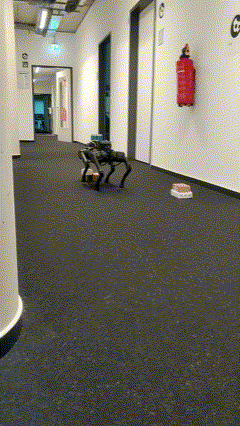
Without elevation mapping
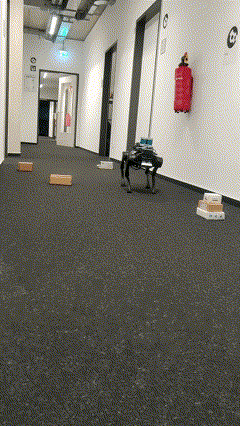
With elevation mapping
The project utilized the IDOG (Intelligent Documentation Gadget) i.e. Unitree A1 quadruped robot as the test platform and focused on real-time integration of elevation data with path planning to improve autonomous navigation in dynamic and complex environments.
Key Features
1. Elevation Mapping
- Implemented a robot-centric 2.5D elevation mapping system using the open-source
elevation_mappingROS package. - Dynamically updated elevation maps in real-time based on terrain height and sensor input.
- Used Intel RealSense D435i depth camera for capturing point cloud data.
2. Path Planning Integration
- Integrated the elevation map into the ROS
costmap_2dframework by adding a custom elevation layer. - Enabled real-time obstacle avoidance and dynamic path re-planning by incorporating height constraints into the navigation stack.
3. Validation and Testing
- Validated the system in a controlled indoor environment with various obstacles and terrain variations.
- Demonstrated successful obstacle detection and navigation through uneven terrains, outperforming traditional 2D mapping methods.
4. Hardware Setup
- Primary computation was performed on Jetson Xavier NX, with elevation mapping offloaded to an Intel NUC running ROS Noetic.
- Fully integrated Intel RealSense D435i for depth sensing and LiDAR for obstacle detection.
Technical Stack
- Programming Languages: C++
- Robotics Middleware: ROS Melodic/Noetic
- Mapping Framework: elevation_mapping
- Costmap Integration: costmap_2d
- Sensor Fusion: Depth Camera (Intel RealSense D435i), LiDAR
- Visualization: RViz
- Computing Units: Jetson Xavier NX, Intel NUC
Results
- Improved navigation accuracy by dynamically integrating elevation data into path planning.
- Enabled the robot to safely traverse obstacles undetectable by traditional sensors, such as LiDAR.
- Successfully demonstrated autonomous navigation in a simulated construction site.
The presentation for this project can be found here